AI Fundamentals for Agriculture Mapping and Geospatial Analysis
AI Fundamentals for Agriculture Mapping and Geospatial Analysis:
AI Fundamentals for Agriculture Mapping and Geospatial Analysis:
Artificial Intelligence (AI) has revolutionized various industries, including agriculture, by providing innovative solutions to challenges faced by farmers and agricultural researchers. In the context of agriculture mapping and geospatial analysis, AI plays a crucial role in enhancing productivity, optimizing resource allocation, and improving decision-making processes. This course on Global Certificate in AI for Mapping and Geospatial Analysis in Agriculture focuses on equipping learners with the necessary knowledge and skills to leverage AI technologies for agricultural applications.
Key Terms and Vocabulary:
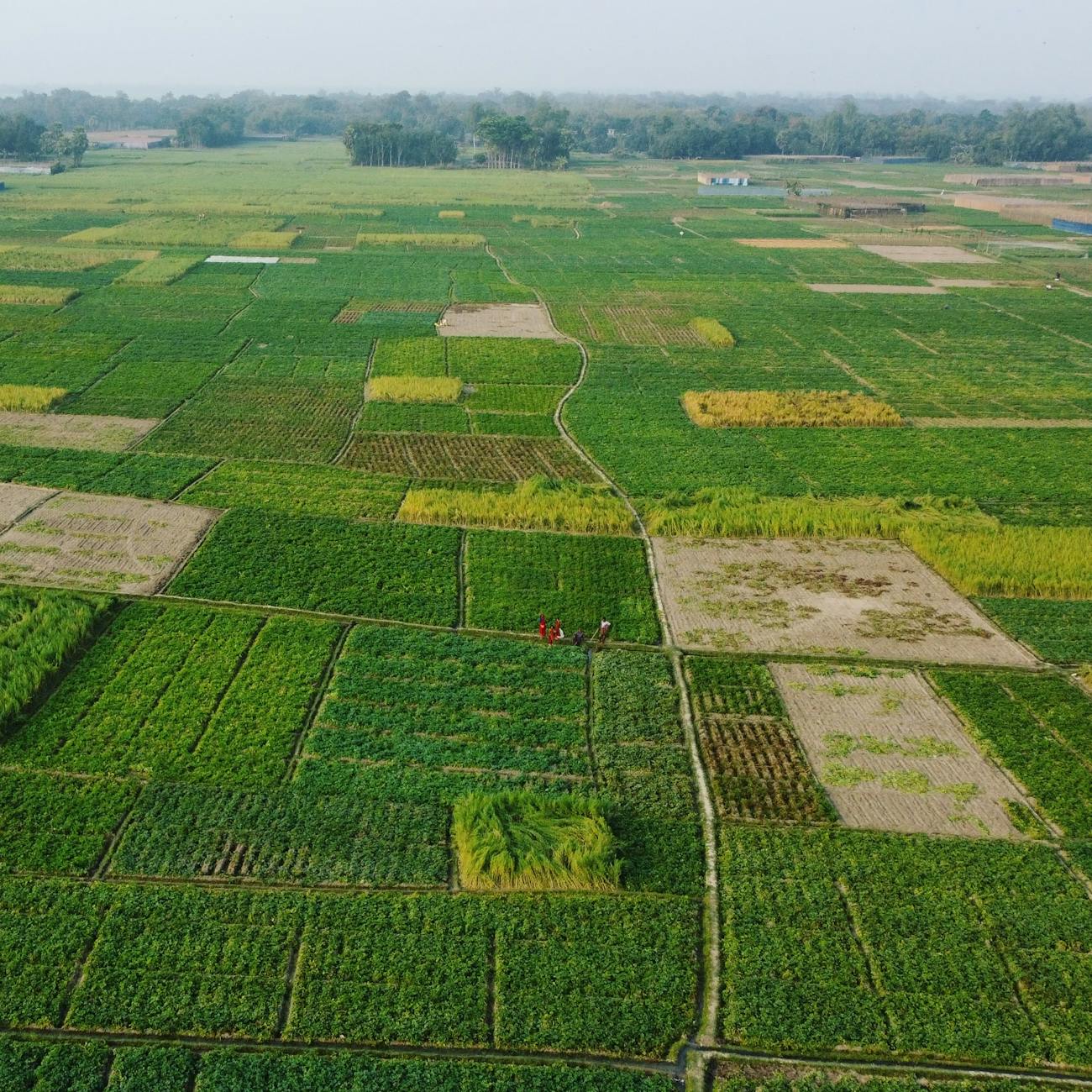
1. Agriculture Mapping: Agriculture mapping involves the use of spatial data to visualize and analyze agricultural landscapes, including fields, crops, and environmental factors. It helps farmers and researchers make informed decisions related to crop management, irrigation, and pest control.
2. Geospatial Analysis: Geospatial analysis refers to the process of gathering, displaying, and interpreting geographic data to understand patterns, relationships, and trends. In agriculture, geospatial analysis helps in identifying optimal planting locations, monitoring crop health, and assessing soil quality.
3. Artificial Intelligence (AI): AI refers to the simulation of human intelligence processes by machines, particularly computer systems. In agriculture, AI can be used to automate tasks, predict crop yields, and optimize resource utilization based on data analysis.
4. Machine Learning: Machine learning is a subset of AI that enables machines to learn from data without being explicitly programmed. In agriculture, machine learning algorithms can analyze historical crop data to predict future yields and identify potential risks.
5. Deep Learning: Deep learning is a type of machine learning that uses artificial neural networks to analyze complex patterns in data. In agriculture, deep learning can be used to classify crop diseases from images or predict weather patterns for better crop management.
6. Remote Sensing: Remote sensing involves collecting information about the Earth's surface from a distance using sensors mounted on satellites or drones. In agriculture, remote sensing data can provide valuable insights into crop health, soil moisture levels, and pest infestations.
7. GIS (Geographic Information System): GIS is a system designed to capture, store, manipulate, analyze, manage, and present spatial or geographic data. In agriculture, GIS technology is used to create maps, visualize data, and make informed decisions about crop planning and management.
8. Precision Agriculture: Precision agriculture is a farming management concept that utilizes technology to optimize crop yields and minimize input costs. AI and geospatial analysis play a key role in precision agriculture by enabling farmers to make data-driven decisions for each individual plant or field.
9. Spatial Data: Spatial data refers to information that has a geographic or locational component, such as coordinates or boundaries. In agriculture mapping and geospatial analysis, spatial data is used to create maps, conduct analysis, and monitor changes in the landscape over time.
10. Yield Prediction: Yield prediction involves using historical data, weather patterns, and other factors to forecast the potential harvest of a crop. AI algorithms can analyze various datasets to predict crop yields accurately, helping farmers plan their operations more effectively.
11. Crop Monitoring: Crop monitoring involves using remote sensing technologies to track the health, growth, and quality of crops throughout the growing season. AI can analyze satellite imagery or drone data to detect early signs of stress, disease, or nutrient deficiencies in crops.
12. Decision Support Systems: Decision support systems are computer-based tools that help farmers and agricultural researchers make informed decisions by analyzing data and providing recommendations. AI-powered decision support systems can optimize planting schedules, irrigation strategies, and pest control measures.
13. Challenges in AI for Agriculture: Despite the potential benefits of AI in agriculture mapping and geospatial analysis, there are several challenges that need to be addressed. These include data quality issues, limited access to technology in rural areas, and the need for specialized skills to implement AI solutions effectively.
14. Opportunities for Innovation: AI presents numerous opportunities for innovation in agriculture, from precision farming techniques to automated machinery. By leveraging AI technologies, farmers can increase productivity, reduce environmental impact, and improve overall sustainability in the agricultural sector.
Practical Applications:
- Smart Irrigation: AI algorithms can analyze soil moisture data, weather forecasts, and crop water requirements to optimize irrigation schedules and minimize water wastage.
- Pest Detection: Using image recognition algorithms, AI can identify pests and diseases in crops from drone or satellite imagery, enabling farmers to take timely action to protect their crops.
- Soil Health Monitoring: AI-powered sensors can monitor soil quality parameters such as pH levels, nutrient content, and compaction, helping farmers make informed decisions about fertilization and soil management practices.
- Crop Yield Prediction: By analyzing historical yield data, weather patterns, and soil conditions, AI can predict crop yields with high accuracy, allowing farmers to plan their harvest and marketing strategies accordingly.
Conclusion:
In conclusion, the Global Certificate in AI for Mapping and Geospatial Analysis in Agriculture provides learners with a comprehensive understanding of how AI technologies can be applied to enhance agricultural practices. By mastering key concepts such as machine learning, remote sensing, and precision agriculture, participants can drive innovation and sustainability in the agriculture sector. This course equips learners with the knowledge and skills needed to leverage AI for agriculture mapping and geospatial analysis, ultimately leading to improved crop yields, resource efficiency, and environmental conservation.
AI Fundamentals for Agriculture Mapping and Geospatial Analysis
Key Terms and Vocabulary
In the realm of agriculture, the integration of Artificial Intelligence (AI) with mapping and geospatial analysis has revolutionized the way farmers, agronomists, and researchers approach crop management, land use planning, and environmental monitoring. This course on AI Fundamentals for Agriculture Mapping and Geospatial Analysis delves into the essential concepts and tools required to leverage AI for enhancing agricultural practices. Let's explore some key terms and vocabulary essential for understanding this field:
1. Artificial Intelligence (AI): AI refers to the simulation of human intelligence processes by machines, particularly computer systems. In agriculture, AI algorithms are used to analyze vast amounts of data to make informed decisions about crop health, soil conditions, and weather patterns.
2. Mapping: Mapping involves the creation of visual representations of spatial data. In agriculture, mapping is crucial for understanding the distribution of crops, soil characteristics, and topographical features of farmland.
3. Geospatial Analysis: Geospatial analysis involves the examination of data that has a geographic or spatial component. It helps in uncovering patterns, trends, and relationships in agricultural data that are tied to specific locations.
4. Remote Sensing: Remote sensing involves the collection of data from a distance, typically using satellites or drones. This technology is integral to capturing high-resolution imagery of agricultural fields for monitoring purposes.
5. Machine Learning: Machine learning is a subset of AI that enables systems to learn from data without being explicitly programmed. In agriculture, machine learning algorithms can analyze historical data to predict crop yields, disease outbreaks, and optimal planting times.
6. Deep Learning: Deep learning is a subfield of machine learning that uses artificial neural networks to analyze complex patterns in data. In agriculture, deep learning models can classify crop types, detect pests, and identify irrigation needs.
7. Precision Agriculture: Precision agriculture involves the use of technology to optimize crop production while minimizing inputs such as water, fertilizers, and pesticides. AI plays a crucial role in enabling precision agriculture practices through data-driven decision-making.
8. Yield Mapping: Yield mapping involves the collection of data on crop yields across a field. By integrating AI algorithms with yield mapping data, farmers can identify areas of high and low productivity, leading to targeted interventions for improved crop yields.
9. Crop Health Monitoring: AI algorithms can analyze remote sensing data to monitor the health of crops. By detecting stress factors such as nutrient deficiencies or pest infestations early on, farmers can take proactive measures to protect their crops.
10. Decision Support Systems: Decision support systems use AI to provide farmers with recommendations for crop management practices. These systems consider factors such as weather forecasts, soil conditions, and market trends to help farmers make informed decisions.
11. Data Fusion: Data fusion involves combining information from multiple sources to create a comprehensive understanding of agricultural systems. By fusing data from satellites, drones, weather stations, and ground sensors, AI can generate actionable insights for farmers.
12. Spatial Data Infrastructure (SDI): SDI refers to the technology, policies, and standards for managing geospatial data. In agriculture, SDI enables the seamless integration of diverse data sources for mapping, monitoring, and analysis purposes.
13. Unmanned Aerial Vehicles (UAVs): UAVs, or drones, are used in agriculture for capturing high-resolution imagery of fields. AI algorithms can analyze drone imagery to assess crop health, detect anomalies, and optimize farming practices.
14. Internet of Things (IoT): IoT devices such as sensors and actuators are deployed in agricultural fields to collect real-time data on environmental conditions. AI can process IoT data to automate irrigation, monitor soil moisture levels, and regulate greenhouse climates.
15. Land Cover Classification: AI models can classify different land cover types such as crops, forests, and water bodies from satellite imagery. This information is valuable for land use planning, environmental monitoring, and ecosystem conservation.
16. Object Detection: Object detection algorithms can identify specific objects such as plants, vehicles, or buildings in satellite or drone imagery. In agriculture, object detection is used for counting crops, measuring field boundaries, and assessing infrastructure.
17. Cloud Computing: Cloud computing provides on-demand access to computing resources over the internet. In agriculture, cloud platforms can store and process large geospatial datasets, enabling scalable AI applications for farmers and researchers.
18. Crop Yield Prediction: AI models can predict crop yields based on historical data, weather forecasts, and soil conditions. By accurately forecasting yields, farmers can optimize harvest planning, resource allocation, and market strategies.
19. Phenotyping: Phenotyping involves the measurement of observable traits in plants, such as leaf area, plant height, and disease symptoms. AI-powered phenotyping tools can analyze images to quantify plant traits and assess genetic traits for breeding purposes.
20. Data Privacy and Security: Given the sensitive nature of agricultural data, it is essential to address issues related to data privacy and security. AI applications in agriculture must comply with regulations and best practices to safeguard farmers' information and prevent cyber threats.
By mastering these key terms and vocabulary related to AI Fundamentals for Agriculture Mapping and Geospatial Analysis, learners can gain a solid foundation in applying AI technologies to optimize agricultural practices. The integration of AI with mapping and geospatial analysis holds immense potential for transforming the agriculture sector and addressing global food security challenges.
AI Fundamentals for Agriculture Mapping and Geospatial Analysis
Introduction
Artificial Intelligence (AI) has revolutionized various industries, and agriculture is no exception. The integration of AI in agriculture mapping and geospatial analysis has significantly enhanced precision farming practices, leading to improved efficiency, productivity, and sustainability. In this course, we will delve into the key terms and vocabulary essential for understanding AI fundamentals in agriculture mapping and geospatial analysis.
1. Artificial Intelligence (AI)
AI refers to the simulation of human intelligence processes by machines, particularly computer systems. In agriculture, AI technologies enable the automation of tasks, predictive modeling, decision-making, and data analysis to optimize farming practices. AI algorithms can process vast amounts of data to provide valuable insights for farmers, leading to more informed decisions and improved outcomes.
2. Mapping
Mapping in agriculture involves the creation of spatial representations of fields, crops, and other agricultural features. Mapping technologies, such as Geographic Information Systems (GIS) and remote sensing, play a crucial role in collecting, analyzing, and visualizing spatial data for decision-making. AI algorithms can enhance mapping processes by improving accuracy, speed, and scalability.
3. Geospatial Analysis
Geospatial analysis involves the examination of geographic data to understand patterns, relationships, and trends in the agricultural landscape. By combining spatial data with AI techniques, farmers can gain valuable insights into soil health, crop growth, pest infestations, and other factors affecting agricultural productivity. Geospatial analysis enables farmers to make data-driven decisions for better resource management and sustainable practices.
4. Precision Agriculture
Precision agriculture is a farming approach that utilizes technology, data, and AI to optimize inputs and maximize outputs in crop production. By using AI algorithms for mapping and geospatial analysis, farmers can precisely target resources such as water, fertilizers, and pesticides to specific areas within their fields. This tailored approach improves efficiency, reduces waste, and enhances overall crop yields.
5. Machine Learning
Machine learning is a subset of AI that enables computers to learn from data without explicit programming. In agriculture, machine learning algorithms can analyze historical and real-time data to make predictions, classify patterns, and automate tasks. By incorporating machine learning into mapping and geospatial analysis, farmers can leverage predictive models to anticipate crop yields, identify anomalies, and optimize farming practices.
6. Remote Sensing
Remote sensing involves the collection of data about the Earth's surface from a distance, typically using satellites, drones, or aircraft. In agriculture, remote sensing technologies capture multispectral and hyperspectral imagery to monitor crop health, detect diseases, and assess soil conditions. AI algorithms can analyze remote sensing data to generate actionable insights for farmers, enabling them to make informed decisions for crop management.
7. Data Integration
Data integration is the process of combining different types of data from various sources to create a unified view for analysis. In agriculture mapping and geospatial analysis, data integration involves merging spatial data, weather data, crop information, and other relevant datasets to gain a comprehensive understanding of the agricultural landscape. AI techniques facilitate data integration by harmonizing disparate datasets and extracting meaningful patterns for decision-making.
8. Image Analysis
Image analysis involves the interpretation of visual data, such as satellite images or drone footage, to extract valuable information about agricultural fields. AI-powered image analysis algorithms can identify crop types, assess vegetation health, detect pests or diseases, and monitor crop growth stages. By automating image analysis processes, farmers can efficiently collect and analyze large volumes of imagery for timely interventions and improved crop management.
9. Predictive Modeling
Predictive modeling uses historical and real-time data to forecast future outcomes or trends in agriculture. By applying AI algorithms to mapping and geospatial analysis, farmers can develop predictive models for crop yield estimation, pest outbreak prediction, and optimal planting schedules. Predictive modeling enables farmers to proactively address challenges and capitalize on opportunities, leading to more sustainable and profitable farming practices.
10. Data Visualization
Data visualization is the graphical representation of data to communicate insights and trends effectively. In agriculture mapping and geospatial analysis, data visualization tools enable farmers to interpret complex spatial data and make informed decisions. AI-powered data visualization platforms can generate interactive maps, charts, and dashboards to visualize geospatial information, helping farmers identify patterns, anomalies, and opportunities for improvement.
11. Internet of Things (IoT)
The Internet of Things (IoT) refers to a network of interconnected devices that collect and exchange data over the internet. In agriculture, IoT sensors can monitor environmental conditions, soil moisture levels, and crop health in real-time. By integrating IoT data with AI algorithms for mapping and geospatial analysis, farmers can gain insights into field conditions, optimize irrigation schedules, and enhance precision farming practices for increased productivity and sustainability.
12. Challenges and Opportunities
While AI fundamentals in agriculture mapping and geospatial analysis offer significant benefits, there are also challenges to overcome. Data quality, privacy concerns, regulatory issues, and the digital divide are some of the obstacles faced by farmers adopting AI technologies. However, by addressing these challenges and leveraging the opportunities presented by AI, farmers can revolutionize their farming practices, improve resource efficiency, and contribute to a more sustainable agricultural sector.
Conclusion
In conclusion, understanding the key terms and vocabulary related to AI fundamentals in agriculture mapping and geospatial analysis is essential for farmers, agronomists, and agricultural professionals looking to harness the power of AI technologies for improved decision-making and productivity. By integrating AI algorithms, machine learning, remote sensing, and data integration into mapping and geospatial analysis processes, farmers can unlock valuable insights, optimize resource management, and drive sustainable agricultural practices for a more prosperous future.
Key takeaways
- This course on Global Certificate in AI for Mapping and Geospatial Analysis in Agriculture focuses on equipping learners with the necessary knowledge and skills to leverage AI technologies for agricultural applications.
- Agriculture Mapping: Agriculture mapping involves the use of spatial data to visualize and analyze agricultural landscapes, including fields, crops, and environmental factors.
- Geospatial Analysis: Geospatial analysis refers to the process of gathering, displaying, and interpreting geographic data to understand patterns, relationships, and trends.
- Artificial Intelligence (AI): AI refers to the simulation of human intelligence processes by machines, particularly computer systems.
- Machine Learning: Machine learning is a subset of AI that enables machines to learn from data without being explicitly programmed.
- Deep Learning: Deep learning is a type of machine learning that uses artificial neural networks to analyze complex patterns in data.
- Remote Sensing: Remote sensing involves collecting information about the Earth's surface from a distance using sensors mounted on satellites or drones.